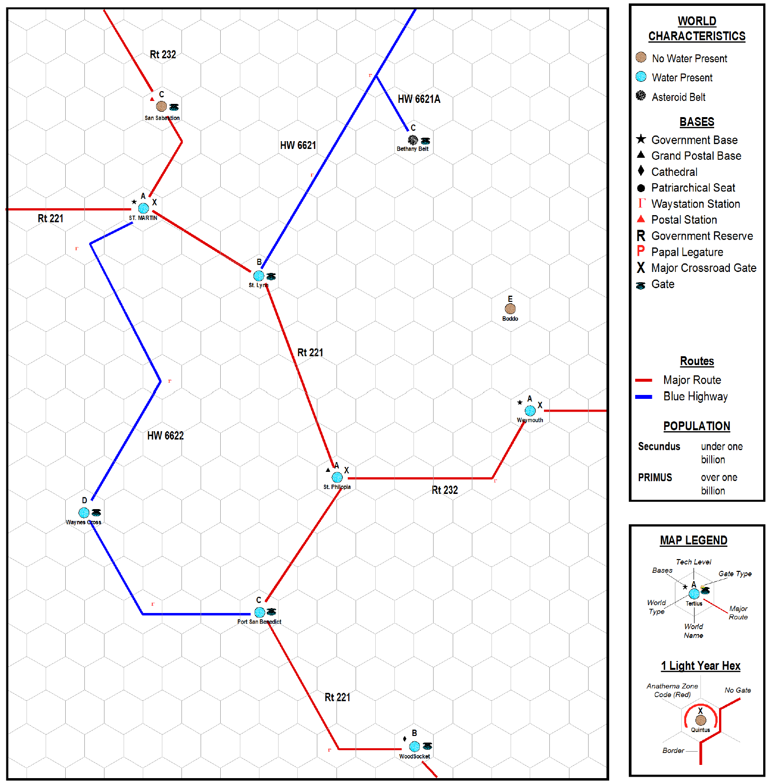
Star systems in real space are spread in three dimensions. In subspace though only the plane of subspace is important and worlds can be considered as existing only on a flat plane. Therefore subspace maps are two dimensional. Maps in New Diasporia are not of standard sizes. There are no regulation size sectors, subsectors or quadrants. In the Highlands maps tend to be based on Diocese or Parishes, irregular areas based on population and ecclesiastical governance. Maps are sometimes based on Counties, a Highland governmental subdivision administered by a Count. Counties sometimes contain several Diocese or may contain only one. Midland maps typically are organized around Blue Highway routes if they exist in the respective area or are based on the same ecclesiastical ordinates as Highland maps. In the Wilds arbitrary navigational groups determine the size and scope of individual maps. A mission map might contain all of the systems under the direction of a specific Church ordinary, that is a bishop, archbishop or designated ordinary, such as an archabbot. A Postal Route map will contain all of the roads on a particular postal route, etc.
On the game map worlds are placed on a field of hexes. Each hex is 1 light year of subspace travel across (times the subspace quality factor.) Planets are represented as either having
no water present, which typically means they have not been terraformed and have hostile environments,
having water present, in which case they either have natural human compatible environments or have been terraformed, or are
asteroid belts, meaning the system has no major planets. The
tech level of the system is designated above the planet. To the left base designations are given. To the right whether the world is a major crossroads or even just has a gate portal. Red lines illustrate the Major Routes and blue lines the Blue Highways. In the Midlands and Wilds a red line along the hexes is used to illustrate borders. Worlds which have been placed under Church Interdiction are noted with a red arc.
Waystations are basically network road truck stops. Fusion powered B/G engine powered spacecraft don't need to stop for fuel, but the human occupants do need to stretch their legs, get grub and buy little bobble headed dolls so superstructure has been constructed around some beacon stations to allow spacecraft passengers a place to rest.
On maps routes are often shown as having doglegs. This is to make them conform to the travel distance between worlds. The convention is to lay out routes so that Waystations are located at the angles of the doglegs.
The map above is of St. Martin Diocese, located in County Cook in the Highlands. There is a Highland Rangers station at St. Martin. The cathedral is located at WoodSocket due to the shrine of Our Lady of WoodSocket being located on that world. There is a Syro-Malabar Catholic Cathedral at St. Martin. Waystations are typically named and numbered based on the route they are on. So the Rt 232 Waystation between St. Philopia and Wymouth is 232-15.
No comments:
Post a Comment